Judge Jones Sentences Defendant for Battery on a Law Enforcement Officer KONK Life Editor, July 17, 2026
DOH-Monroe, Guidance/Care Center, and Monroe County Coalition Distribute Free Narcan Kits During Revive Awareness Day KONK Life Editor, July 17, 2026
KEY WEST LOU / HEGSETH WANTS TO TEST THE TESTOSTERONE LEVEL OF ALL TROOPS KONK Life Editor, July 17, 2026
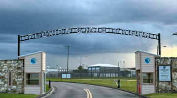
2 executions scheduled for same day in Florida for the first time in more than 60 years KONK Life Editor, July 17, 2026
Hernia Remains One of the Most Common Surgical Conditions in the United States KONK Life Editor, July 16, 2026
News stories Flood Waters Rise High Enough to Submerge Some USGS Instruments SHARE ON: Guy deBoer — September 17, 2018 Flood Waters Rise High Enough to Submerge Some USGS Instruments Six North Carolina streamgages surpaAlready a subscriber? log in. This story is free for you Create a free account and get more of KonkLife's top stories directly to your inbox. Email Password Or, subscribe for unlimited access


No Comment