NOAA establishes temporary special use area to protect relocated Florida Keys coral nursery
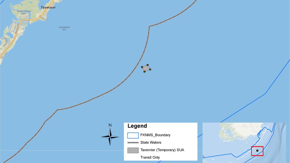
In response to rising ocean temperatures, NOAA has used its emergency authority to create a temporary special use area in Florida Keys National Marine Sanctuary to protect endangered corals that have been relocated to a nursery in federal waters approximately five miles southeast of Tavernier, Florida. The temporary regulation lasts 60 days, with the option for one 60-day extension, and prohibits all entry except for continuous transit without interruption.
“It’s critical for managers to have the ability to quickly respond to urgent situations,” said Sarah Fangman, sanctuary superintendent. “Coral bleaching created by the recent marine heatwave has forced practitioners into an emergency response, moving endangered corals to cooler, deeper water. This Temporary Special Use Area will limit physical impact to sensitive coral nursery stock from anchoring, unintentional fouling of fishing gear, and bottom tending fishing gear including traps.”
Expert forecasts suggest that extreme ocean temperatures will likely persist until at least October 2023. Coral nursery stock located in shallow nurseries (20-30 feet in depth) are most at risk, where nearshore protected environments heat up much more intensely than offshore locations. The relocated site, protecting 2,800 coral fragments, has been established in 70-feet of water.
“The temporary rule is an important management tool that the state and FKNMS have, and this is a perfect example of how it should be used,” said Ken Nedimyer, technical director for Reef Renewal USA. “We ask that fishermen and local boaters be understanding about the need for this temporary closure. Many of the corals being held in this nursery are the sole remaining colonies left from what used to be thriving thickets of staghorn or elkhorn, so the future prospects for restoration depend on keeping them alive. We anticipate moving the corals back to our Tavernier nursery sometime in October or November, so the duration of the closure is just about right.”
The emergency action is taken in accordance with the sanctuary’s original 1997 regulations: “where necessary to prevent or minimize the destruction of, loss of, or injury to a Sanctuary resource, any and all activities are subject to immediate temporary regulation, including prohibition.” Because further damage to these sensitive nursery corals would occur if the prohibition implemented by this rule was delayed, NOAA found good cause to waive notice and public comment, as both would be impracticable and contrary to the public interest.
It has been 20 years since the sanctuary utilized the emergency provision. In 2003, a similar coral stress event resulted in a Temporary No-Entry Zone in the White Bank Dry Rocks Area near Key Largo.
The GPS location of the .07 square-mile area can be found in the free, Marine Sanctuary Explorer mobile app by searching “Tavernier (Temporary) Special Use Area.”
Boundary coordinates are as follows:
|
Point No |
Latitude |
Longitude |
|
1 |
24.96934 |
-80.44378 |
|
2 |
24.97076 |
-80.43955 |
|
3 |
24.96765 |
-80.43759 |
|
4 |
24.96612 |
-80.44186 |
|
5 |
24.96934 |
-80.44378 |


No Comment