COMMISSIONERS ADOPT UPDATED UNIFIED REGIONAL SEA LEVEL RISE PROJECTIONS TO USE FOR FUTURE PLANNING
MONROE COUNTY, FL – The Monroe County Board of County Commissioners adopted the updated Unified Regional Sea Level Rise Projections of the Southeast Florida Regional Climate Change Compact and directed staff to utilize the updated projections as the basis for future sea level rise adaptation planning activities. This action provides the Board with sea level rise projections and a support document to guide risk assessments and sea level rise adaptation planning county-wide and in coordination with the region of southeast Florida. The County is using these revised projections in its Roads Adaptation Study, which is currently underway.
This is the third technical Regionally Unified Sea Level Rise Projection document that has been produced that is updated every four to five years by the Climate Compact technical team. The team consists of members from the academic community, federal agencies, local government staff, and includes the most up-to-date, peer-reviewed literature, and climate modeling data.
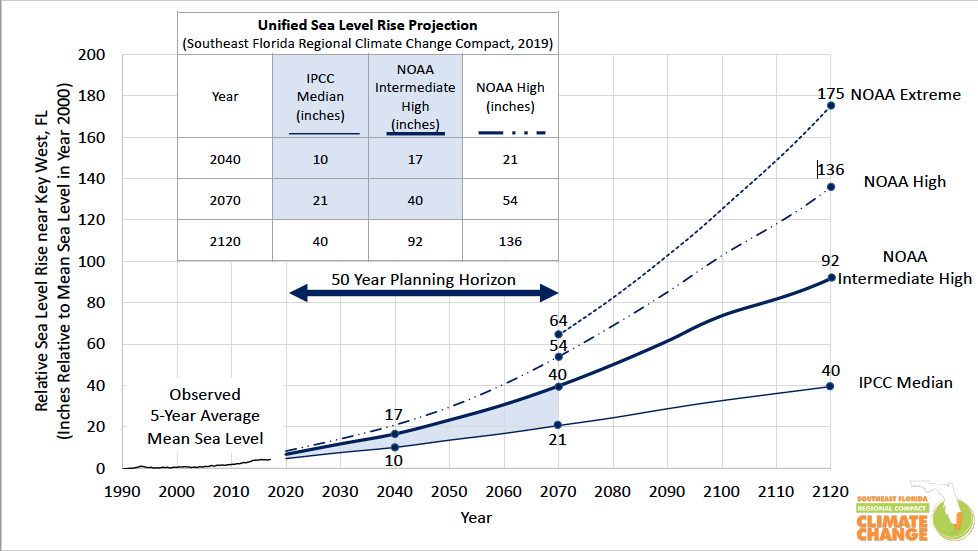
Estimates of sea level rise are provided from a baseline year of 2000, and the planning horizon has been extended to 2120, in response to climate scenarios by federal agencies extending beyond the year 2100 and the need for planning for infrastructure with design lives greater than 50 years.
Sea level measured at the Key West gauge has risen approximately 3.9 inches from 2000 to 2017. According to the graph, mean sea level rise is projected to be the following:
- 10 to 17 inches from 2000 to 2040 (sea levels have already risen 4 inches through 2017, this means a net additional 6 to 13 inches is projected from 2018 to 2040.)
- 21 to 54 inches from 2000 to 2070 (sea levels have already risen 4 inches through 2017, this means a net additional 17 to 50 inches from 2018 to 2070.)
- 40 to 136 inches by 2120
The projection considers regional effects, such as thermal expansion from the warming of the Florida Current, that produce differences in Southeast Florida’s rate of sea level rise compared to other areas in global projections. The NOAA extreme curve is displayed on the Unified Regional Sea Level Rise Projection for informational purposes but is not recommended for design.
The climate is changing, manifesting in significant impacts for the Southeast Florida region, including increasing average temperatures, more intense storm events, and rising sea levels. The Southeast Florida Regional Climate Change Compact is the result of Miami-Dade, Monroe, Palm Beach, and Broward counties recognizing the need to create a regionally unified program to ensure consistency in planning and policy in the four-county area.
To see the report in its entirety, visit www.monroecounty-fl.gov/


No Comment