


PeopleforBikes just released its ninth annual City Ratings report, and Key West’s score of 63 ranks #3 in Florida — and #232 out of 3,019 places rated across the country, the top 8 percent. Not bad for our little island paradise.
Cities are scored on a 100-point scale using a Bicycle Network Analysis, or BNA, which measures how easily people can reach everyday destinations — jobs, schools, parks, grocery stores, essential services — by connected, safe, low-stress bike routes. PeopleforBikes calls a score of 50 the critical tipping point toward real bikeability, and only 555 of those 3,019 places cleared it. On an island this small and flat, we already know the answer in our bones: yes, you can get most places by bike.
So, a good score isn’t a surprise. The real questions are why it dropped — we were at 69 last year — and why we aren’t doing even better, given everything we’ve got going for us.
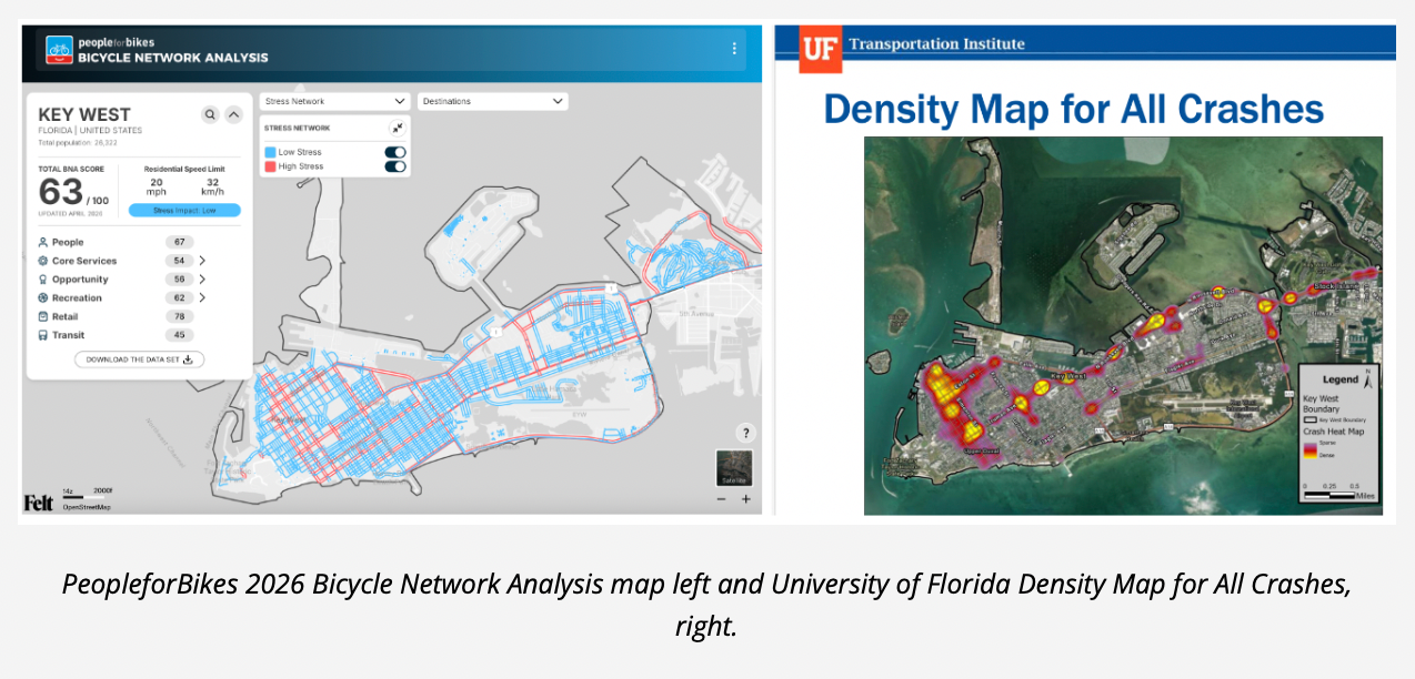
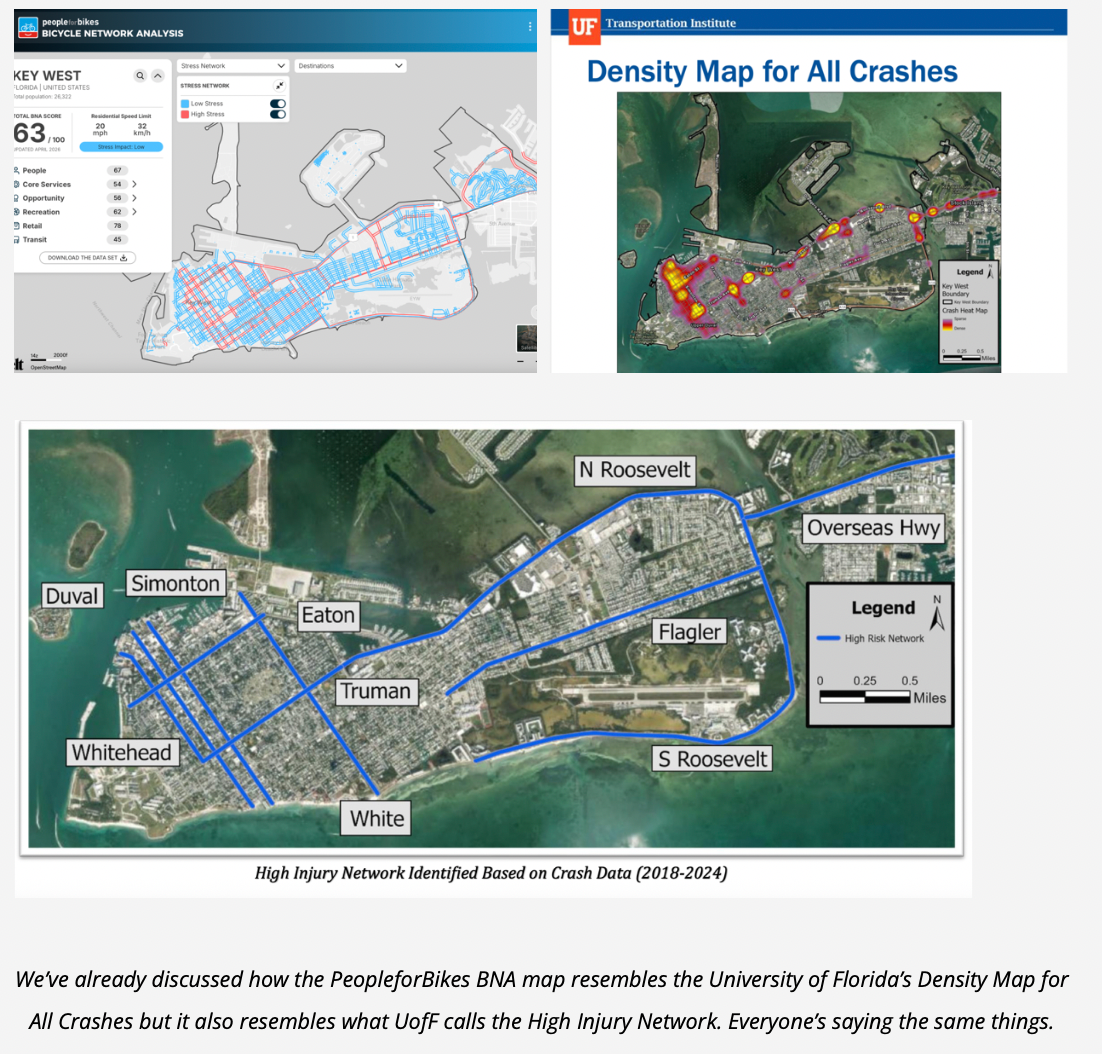
Here’s the thing that caught my eye. This year’s BNA “Stress Network” map of Key West looks eerily familiar. It’s almost a tracing of the University of Florida’s analysis of our actual police crash data — 2018 to 2024, cars, pedestrians, and bikes — in the recently adopted Key West Safety Action Plan. Two different reports. Two different methods. No shared data. PeopleforBikes looked at street speed and bike infrastructure. UF looked at where people actually crashed. And they landed on the same streets. That’s not a coincidence. It’s confirmation: where it’s unsafe for bikes, it’s unsafe for everybody.
The good news is we’ve already got a plan for this. Below, let’s walk through Key West’s 2026 numbers, why the score slipped even though it’s still strong, how we stack up against other cities, what the stress map and the crash map are telling us together, and what we do about it. Let’s go.
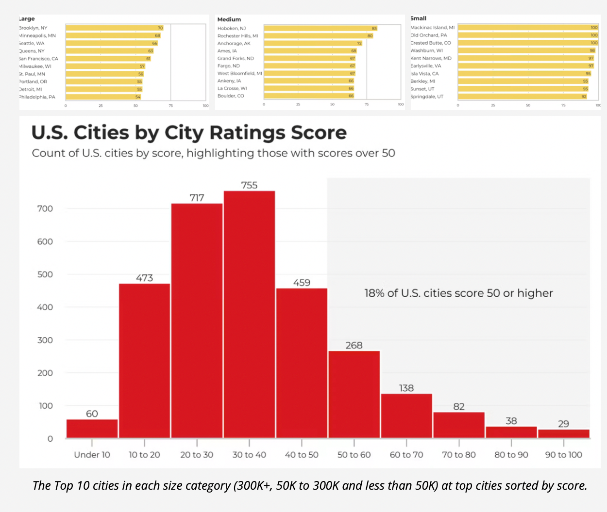
The 2026 Numbers in Context
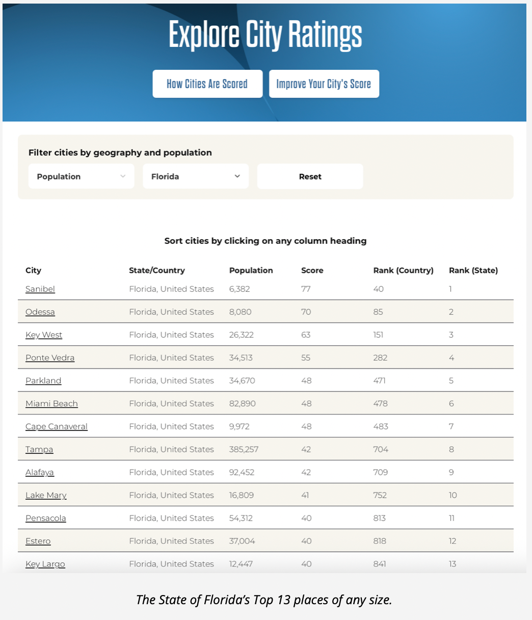
This is PeopleforBikes’ ninth annual ranking and our seventh time covering Key West’s score (2025, 2024, 2023, 2022, 2021, 2020). At 63 out of 100, we’re third in Florida and number 232 of 3,019 places nationwide — the top 8 percent.
About That Drop to #3 in Florida
For the past few years, we’ve been number one in Florida. What happened? PeopleforBikes added about 500 new places this year, and two of them landed above us. Sanibel scored 77 — a 6,400-person barrier island on Florida’s Gulf coast wrapped in separated bike paths. Odessa scored 70 — a small census-designated community in Pasco County, north of Tampa.
Now, I’ll be honest about something I’ve raised with PeopleforBikes before: there’s a built-in tilt toward tiny places in how this works. The BNA measures whether you can reach destinations on low-stress streets — and in a very small community, even a little bit of good infrastructure can connect the whole place. It’s part of why the very top of the national list is dominated by small resort towns. So Sanibel and Odessa sitting above us isn’t the full story.
Because look past those two, and the picture changes. The first full-size city below Key West is Ponte Vedra at 55 — eight points back. Then the rest of urban Florida falls off a cliff: Miami Beach 48, Tampa 42, Orlando 37, Miami 28. Key Largo, right in our own backyard, 40. The mainland Florida scores are, frankly, dreadful — but that’s what you’d expect from places built entirely around the car. So we’re not in third place in any way that matters. We’re alone at the top of real-city Florida. And that’s exactly the kind of only-in-Key-West distinction worth protecting. More on that in a bit.
Some Sister-City and Other Comparisons
How does that 63 stack up against places more like us? We often think of Provincetown, Massachusetts — another tourist town at the end of the line. In days of yore, there was a steady stream of Key West workers heading up to the Cape for the summer season and circling back here come fall. Ptown scored 75. That’s something to strive toward. A few others worth a look: Boulder, Colorado — the national gold standard for a city that made bikes its brand — sits at 66, just three points ahead of us. Rehoboth Beach, Delaware, came in at 59. And then the cautionary tales: St. Augustine, Florida — our state’s other famous historic, walkable, tourist-driven town — scored 21. Asheville, North Carolina, 19. Ocala, where so many Conchs landed in the ’70s, ’80s, and ’90s, also 19. Places with a similar vibe: New Orleans, Louisiana, 33, and Park City, Utah, 53.
The point? The places everyone assumes are bikeable mostly aren’t — and Key West is doing pretty well. Our bikeability could be a real calling card.
Why Key West’s Score Dropped from 69 to 63

Here’s what I want to be clear about: biking in Key West did not get more dangerous between last year and this year. Ryan Stachurski, the City’s Multi-Modal Coordinator, said as much to me, and he’s right. And we’ve written about that good and steady progress recently. So how does the score drop six points if nothing on the ground got worse?
Because last year’s map was the problem. It told us our streets were safer than they really were.
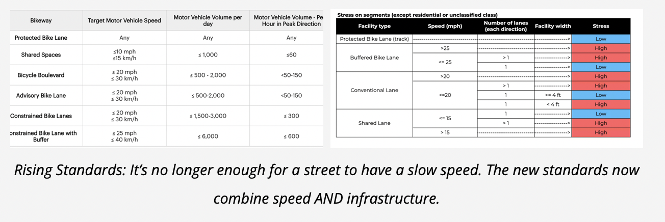
The score didn’t drop because we tore out bike lanes — we’ve added them the past couple of years, on United and South Streets. It dropped because PeopleforBikes changed the ruler. Under new national design standards from NACTO, a painted bike lane on a street faster than 20 mph no longer counts as low-stress — because it isn’t. That’s why Whitehead, Duval, Simonton, and Eaton, among others, turned red: paint, or nothing at all, on streets where cars move too fast. The old score leaned mostly on speed limits and downtown City streets are mostly 20 mph – so in the old rubric were considered safe. This year’s methodology looks at the real infrastructure — shared lanes, conventional lanes, buffered lanes, protected lanes — alongside speed, and whether any of it actually connects.
This shows up when you look at last year’s map and you’ll see the issue: in all of Old Town, only Flagler and Truman showed up red. Everything else read as comfortable. But Whitehead, Simonton, Duval, and Eaton have no real bike infrastructure — and on the Safety Plan’s crash map, they’re exactly where the wrecks pile up. Last year’s map said low-stress. The crash data said otherwise. This year’s map finally tells the truth.
And the proof it’s not just us? Nationally, the bar went up, and the average score still climbed, from 25 to 36. The standards got stricter and the country got better at the same time. We slipped against a rising tide.
Where We Stand — 63 Is Good
63 still clears PeopleforBikes’ “great place to bike” line of 50 comfortably. We’ve got real advantages — four miles by two, flat, warm, gridded, a mostly 20 mph island. And we’ve earned part of the score: brand-new lanes on South and United where there were none, the rebuilt Staples Avenue Bike/Ped Bridge, improvements to the Crosstown Greenway, more bike parking and fix-it stations across the island. But “best in Florida” was always partly a gift of geography. The question this year’s more honest map puts to us is the one worth asking: if we start this far ahead, why aren’t we finishing?
One footnote on the score, since it’ll come up: our lowest category is transit, at 45. Don’t read too much into it. On an island this size, the transit metric barely matters — it’s really built for big cities, and plenty of top-scoring small towns have no transit at all. The BNA counted essentially the airport and the Key West Express boat and the little bit of fixed transit we have left. It’s not where our work is – at least as it pertains to bike safety.
The BNA Stress Map and the Crash Map Are the Same Map
The BNA Stress Map’s red streets and the University of Florida’s Density Map for All Crashes are the same streets. The bike model flags them as high-stress; the crash data flags them as where people actually get hurt — and sometimes killed. That’s independent confirmation that the red isn’t an abstraction. It’s a casualty map. And the crashes include cars. Fixing these streets isn’t a favor to cyclists. It’s where drivers, walkers, the kid on an e-bike, and the tourist on a scooter are getting hurt. The bike network’s weak points and the island’s deadly points are the same points. Even if you’ll never ride a bike, you drive and walk these streets — so we all have a stake in fixing them.
Shouldn’t Key West Be Doing Better?
Yes, we should. Key West has natural advantages most cities lack. We’re small. Flat. A compact street grid. Good weather year round. And in recent years we’ve put real money into infrastructure. On top of that, we don’t have to invent any new roadmaps — we’ve already adopted a Bicycle/Pedestrian Master Plan (2019) and just recently a Safety Action Plan, with 36 projects, 23 policies, price tags, and a federal Safe Streets funding path. Those plans name the exact streets we need to fix. The BNA red map, the UF crash map, and the City’s own project list are all pointing at the same corridors.
Ryan Stachurski sees the BNA the same way — as a map of where to work next, not a verdict. The analysis, he says, “can highlight areas of opportunity when it comes to improving bicycle mode comfort and connectivity” — and some of those areas, he notes, “have already been reflected in other plans and targeted for future improvement, or in some cases, may have already been improved.” He encourages riders to flag the rough spots themselves through Key West Connect, the City’s request system for unsafe crossings and improvements.
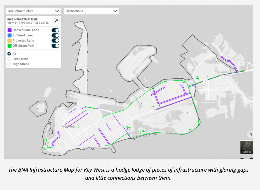
The fix is funding the plans and making connections — stitching the disjointed lanes into a network. Because the new rubric rewards networks, not one-off projects. Look at the BNA Infrastructure Map of Key West and you’ll see the problem: lots of little pieces of bike infrastructure with gaps between them, not at all stitched together. The whole point is a connected, low-stress network. THAT is what gets people riding, because people are afraid when the infrastructure just abruptly ends.
A quick caveat: the PeopleforBikes Infrastructure Map doesn’t yet include South Street, and it doesn’t seem to recognize the Crosstown Greenway. The maps are built on OpenStreetMap data, so just fixing those entries may bump our score on its own.
But here’s what we meant at the top of the story when we said doing better can be our calling card – the only-in-Key West distinction worth protecting. Year after year, we track these rankings and dig into the PeopleforBikes data not for the score, but for what the score represents. The walkable, bikeable island is the product. It’s what sets us apart from all those car-centric places on the mainland. It’s what the engaged visitor flew here for. It’s the Golden Goose that funds everything else — and done right, THAT’s Key West’s calling card.
It’s also the most direct affordability lever we’ve got: on a flat four-by-two island, a bike — or an e-bike — is the cheapest way for a worker to live here without a $580-to-$1,100-a-month car. Better bike streets keep workers, keep character, keep Key West Key West.
What Needs to Happen Next
Fund the Safety Action Plan’s projects. Chase the Safe Streets grant match. Connect the bike lanes we already have. Follow the red — the BNA’s map and UF’s map already drew the to-do list. And at upcoming candidate forums, it’s fair to ask everyone running for commission or mayor one straight question: Will you fund the Safety Action Plan and the buildout of the Bike/Ped Master Plan?
So, back to where we opened. Two maps, drawn by people who never spoke to each other, using two completely different methods, agreeing on which streets are dangerous. We can keep treating that as a bike story and shrug. Or we can see it for what it is — a safety story, an affordability story, a keeping-Key-West-Key-West story — and finish the plans already sitting on the shelf. If it’s unsafe for bikes, it’s unsafe for everybody. That’s the whole thing, right there.
# # #
Chris Hamilton is the founder of Friends of Car-Free Key West & Duval Street/Historic Downtown, a local advocacy group championing sustainable mobility and vibrant public spaces. Subscribe to the blog and follow on Facebook, Twitter, and Substack for updates. All stories are cross posted at KONK Life News. Originally from Washington, D.C., Chris spent over two decades leading nationally acclaimed initiatives in transit, biking, walking, and smart growth for Arlington County, VA’s DOT. Since moving to Key West in 2015, he has embraced a car-free lifestyle downtown, dedicating his time to non-profits and community projects. Explore all Streets for People column articles here.
[livemarket market_name="KONK Life LiveMarket" limit=3 category=“” show_signup=0 show_more=0]

No Comment